
HG-S02 CADabra · CAD to GIS

From CAD drawing to a GIS layer you can trust
CADabra takes Israeli statutory plans (MABAT) and AS-MADE surveys as DWG or DXF, converts them into GIS layers, checks topology and spec compliance, writes a quality report and publishes to your organization's ArcGIS Online. A CAD layer it doesn't recognise waits for your decision instead of a guess.
Live
- Plan no.
- HG-S02
- Scale
- 1:1,250
- Sheet
- 02/05
- Updated
- 11.2026
- Status
- Live
The problem
Drawings arrive as DWG. GIS needs layers.
Statutory plans and contractors' AS-MADE surveys arrive as AutoCAD files. Converting them to GIS by hand takes days, depends on one person, and the quality checks get lost along the way: lines that never close into polygons, layers with unexpected names, Hebrew text that turns into garbage, and a coordinate system nobody verified.
Two modules
MABAT and AS-MADE
- MABAT CAD ingestion for statutory plans, spatial joins, topology QC, plan-boundary (GVUL) creation, lot-number (CELLNO) refresh, a bulk editor, reports, an attribute table, and distance, area and angle measuring.
- AS-MADE Survey DWG/DXF to GIS under the Israeli national mapping spec 2.1: a conversion class per feature (to spec, estimated or not converted), a fixed set of point, line and polygon layers in ArcGIS Online with Hebrew domains and spec symbology, a CAD view, a quality grade and heights.
What CADabra does
From the file to a published layer
- DWG, DXF or ZIP Upload single files or a bundle. DWG files are read with LibreDWG.
- Coordinate system Detects the Israeli Transverse Mercator grid (ITM, EPSG:2039) and transforms between ITM and WGS84 using the Survey of Israel 108021 transformation.
- Hebrew text from legacy drawings Recovers Hebrew text in DOS and Windows encodings, keyboard fonts and MTEXT.
- Unknown layers A CAD layer that isn't in the mapping dictionary is never converted silently. It waits for a decision, with a suggested family.
- Quality report An HTML or PDF report, in Hebrew or English, with a quality grade and maps.
- Open-format export GeoJSON, Shapefile, KML, File GDB and GeoPackage in a single ZIP.
- Publish to ArcGIS Online Publishes to your organization after checking the user's privileges. CADabra never deletes ArcGIS Online items.
- Sharing Share a work session with users in your organization for viewing or editing, plus share links.
- Organization management Organizations, groups, module access, quotas, a geofence per organization and usage screens.
- Security Two-step verification with recovery codes, sign-in through your organization's identity provider (OIDC SSO), an IP allow-list, an audit log, and CAD parsing in an isolated sandbox.
- Hebrew and English A full interface in both languages, right-to-left and left-to-right.
How it works
Six stations from drawing to layer
-
ST-01
Upload
A DWG, DXF or ZIP into the MABAT or AS-MADE module.
-
ST-02
Read and locate
The drawing is parsed, Hebrew text is recovered and the coordinate system is detected.
-
ST-03
Convert
Each CAD layer is mapped to a GIS layer through the mapping dictionary. An unknown layer stops for your decision.
-
ST-04
Check
Topology and spec checks, with a conversion class for every feature.
-
ST-05
Report
A quality report with a grade and maps, in Hebrew or English.
-
ST-06
Export or publish
A ZIP in open formats, or direct publishing to your organization's ArcGIS Online.
From a real demo
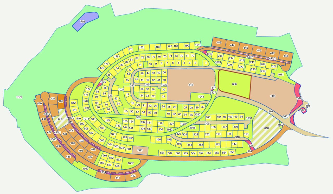
Sample AS-MADE drawing M652
The result for one demo drawing. Every drawing is different, which is why the report shows the result for your file.
Who it's for
For anyone who receives drawings and needs layers
- Municipal engineering and planning Bring contractors' AS-MADE files and statutory plans into the authority's layers.
- Regional councils and planning committees Pre-check plans, keep plan boundaries and lot numbers current.
- Water and sewage corporations As-built surveys that land in spec-compliant GIS layers, with a quality report.
- Survey and planning offices Check the deliverable before it goes to the client, and export in whatever format they ask for.
Use cases
Where CADabra replaces manual work
- Contractor AS-MADE into infrastructure layers The survey is converted to spec and lands in the fixed point, line and polygon layers in ArcGIS Online, with Hebrew domains.
- Pre-checking a plan Topology QC and a report before the plan moves on, so issues get fixed in-house rather than after review comments.
- Plan boundaries and lot numbers Create the plan boundary and refresh lot numbers straight from the drawing.
- Legacy drawings with Hebrew Files saved in old encodings open with readable Hebrew text.
Integrations and formats
CAD in, open formats out
- AutoCAD DWG / DXF Input
- ArcGIS Online Publishing to your organization
- Shapefile Export
- File Geodatabase Export
- GeoPackage Export
- GeoJSON / KML Export
- OIDC SSO Sign-in through your identity provider
- Google Cloud Hosting
Status
Live in production
CADabra runs as a production release at cadabra.city, behind sign-in. Work with the first customers runs as a pilot, and the platform ships in regular releases.
S-10
Got a drawing waiting to be converted?
In a demo we'll run a drawing, walk through the checks and the quality report, and show the layers arriving in ArcGIS Online.